 Home Save Chabot History EBRPD Watch Biotics Contact Us Links
Project Impacts are Misrepresented in the City's Environmental Impact Report
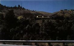
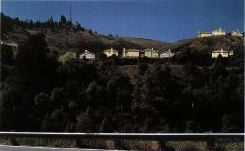
The first picture is a scan taken from Figure 3.8-5, Boulders Residential Development Draft Environmental Impact Report (EIR) prepared for City of San Leandro. The EIR picture is suppose to show us how the proposed project might look from Lake Chabot Dam. Notice how the houses are hidden by shadow . Some houses, below the Fairmont radio tower, are completely hidden in the dark. Why does the City's EIR show an unrealistic picture like this? Compare the City's picture to the second picture prepared by San Leandro Coalition for Responsible Planning (SLCRP). Our picture shows a more realistic view of how the project will look to park visitors. YOU CAN HELP! Contact City of San Leandro officials and tell them you want to see realisic pictures that show the real impacts of housing units proposed for Lake Chabot Park! (Scroll to view a larger pictures)
EIR Picture
Scan of Figure 3.8-5, "Existing and Proposed Lake Chabot Dam View: Proposed"; Boulders Residential Development Draft Environmental Impact Report, page 3.8-10 (City of San Leandro, California, October 23, 1997).
Our Picture
Enhanced image by SLCRP last revised: February 11, 2022 |
||||||||||||||||||||||
.JPG)
.JPG)